Camp Ripley Sentinel Landscape
-
Minnesota
-
Established 2015
About
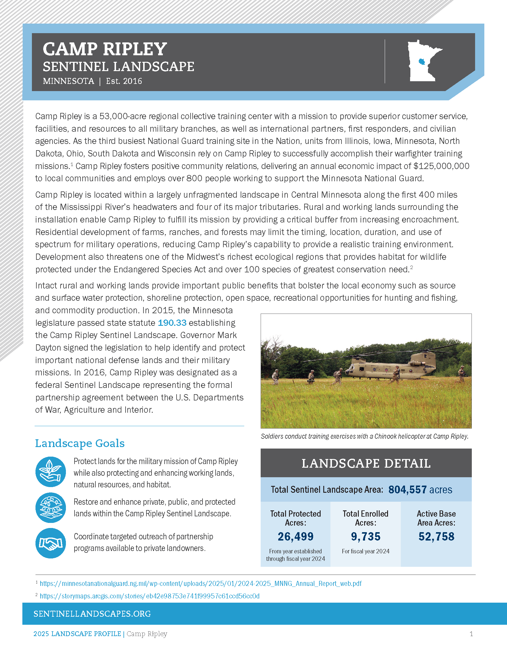
Camp Ripley is a 53,000-acre regional collective training center with a mission to provide superior customer service, facilities, and resources to all military branches, as well as international partners, first responders, and civilian agencies. As the third busiest National Guard training site in the Nation, units from Illinois, Iowa, Minnesota, North Dakota, Ohio, South Dakota and Wisconsin rely on Camp Ripley to successfully accomplish their warfighter training missions.1 Camp Ripley fosters positive community relations, delivering an annual economic impact of $125,000,000 to local communities and employs over 800 people working to support the Minnesota National Guard.
Camp Ripley is located within a largely unfragmented landscape in Central Minnesota along the first 400 miles of the Mississippi River’s headwaters and four of its major tributaries. Rural and working lands surrounding the installation enable Camp Ripley to fulfill its mission by providing a critical buffer from increasing encroachment. Residential development of farms, ranches, and forests may limit the timing, location, duration, and use of spectrum for military operations, reducing Camp Ripley’s capability to provide a realistic training environment. Development also threatens one of the Midwest’s richest ecological regions that provides habitat for wildlife protected under the Endangered Species Act and over 100 species of greatest conservation need.2
Intact rural and working lands provide important public benefits that bolster the local economy such as source and surface water protection, shoreline protection, open space, recreational opportunities for hunting and fishing, and commodity production. In 2015, the Minnesota legislature passed state statute 190.33 establishing the Camp Ripley Sentinel Landscape. Governor Mark Dayton signed the legislation to help identify and protect important national defense lands and their military missions. In 2016, Camp Ripley was designated as a federal Sentinel Landscape representing the formal partnership agreement between the U.S. Departments of War, Agriculture and Interior.

Total Funding by Partner
| Partner | FY2015 | FY2016 | FY2017 | FY2018 | FY2019 | FY2020 | FY2021 | FY2022 | FY2023 |
|---|---|---|---|---|---|---|---|---|---|
| USDA | $0.78M | $0.83M | $0.52M | $1.24M | $1.75M | $1.02M | $1.30M | $1.12M | $0.44M |
| DOW | $0.00M | $0.00M | $0.00M | $0.00M | $0.00M | $0.00M | $0.00M | $0.00M | $0.00M |
| DOI | $0.00M | $0.00M | $0.00M | $0.00M | $0.00M | $0.30M | $0.00M | $3.78M | $0.00M |
| State | $6.44M | $7.28M | $3.74M | $6.95M | $3.20M | $5.69M | $0.98M | $0.98M | $0.23M |
| Local | $0.00M | $0.00M | $0.00M | $0.00M | $0.00M | $0.00M | $0.01M | $0.00M | $0.00M |
| Private | $0.00M | $0.00M | $0.00M | $0.00M | $0.00M | $0.85M | $0.12M | $0.18M | $0.00M |
| DoD | $2.84M | $3.56M | $8.93M | $4.05M | $0.00M | $0.50M | $0.50M | $0.75M | $1.30M |
Total Acres Protected and Enrolled
| Acres Protected (Since Designation) | 23625 |
|---|---|
| Acres Enrolled (During FY23) | 45266 |
Our Partners
Federal Partners
- U.S. Army National Guard
- U.S. Department of Agriculture, Farm Service Agency (FSA)
- U.S. Department of Agriculture, Forest Service (USFS)
- U.S. Department of Agriculture, Natural Resource Conservation Service (NRCS)
- U.S. Department of the Interior, Fish and Wildlife Service (USFWS)
- U.S. Department of the Interior, National Park Service (NPS)
- U.S. Department of War, Readiness and Environmental Protection Integration (REPI)
Private Partners
Resources
-
Camp Ripley Sentinel Landscape Profile
Meet the Coordinators

Kayli Overland
Kayli Overland serves as the Camp Ripley Sentinel Landscape (CRSL) Coordinator in Minnesota. She has been in this role since 2024 as an employee of the private organization; LegacyWorks Group. The CRSL Partnership is composed of over twenty key partners who focus on land protection, restoration and management, and community engagement and coordination.
Kayli has worked in the private, environmental field since graduating from Gustavus Adolphus College with a bachelor's degree in Environmental Studies. Previously, she worked for The Nature Conservancy's MN/ND/SD chapter for seven years, most recently as the Mississippi Headwaters Conservation Coordinator. In that role she focused on land protection and restoration programs in the Mississippi Headwaters Basin, convened and coordinated partnerships, and supported the Camp Ripley Sentinel Landscape program.

Raenah Bailey
Midwest Resilience Specialist for the Southern Indiana Sentinel Landscape and the Camp Ripley Sentinel Landscape.
Her passion for environmental science emerged during college, fueled by field-based courses, volunteering with Shirley Heinze Land Trust, and spending time at the Indiana Dunes. This led her to pursue graduate studies at Indiana University in Indianapolis, where her research focused on nitrogen’s impact on water quality in the Upper White River Watershed. She used methods like risk assessments and stormwater modeling to improve local water ecosystems. Importantly, she shared her findings not just within academic circles but also with the broader community, utilizing interactive web applications and educational outreach tools to promote awareness and understanding of water quality issues.
During her graduate studies, Raenah gained valuable experience through various internships and jobs across different sectors. Most notably, she engaged with the local community by working with private organizations such as Reconnecting to Our Waterways and Friends of Belmont Beach. She used these opportunities to connect residents with environmental science, raising awareness about local ecological challenges. Additionally, she collaborated with the Indianapolis Airport Authority on sustainability projects, where she contributed to the development and implementation of their Sustainable Management Plan over several years.
In 2024, Raenah earned her PhD in Applied Earth Sciences, a culmination of years of dedicated research, community outreach, and environmental advocacy.