Fort Huachuca Sentinel Landscape
-
Arizona
-
Established 2015
About
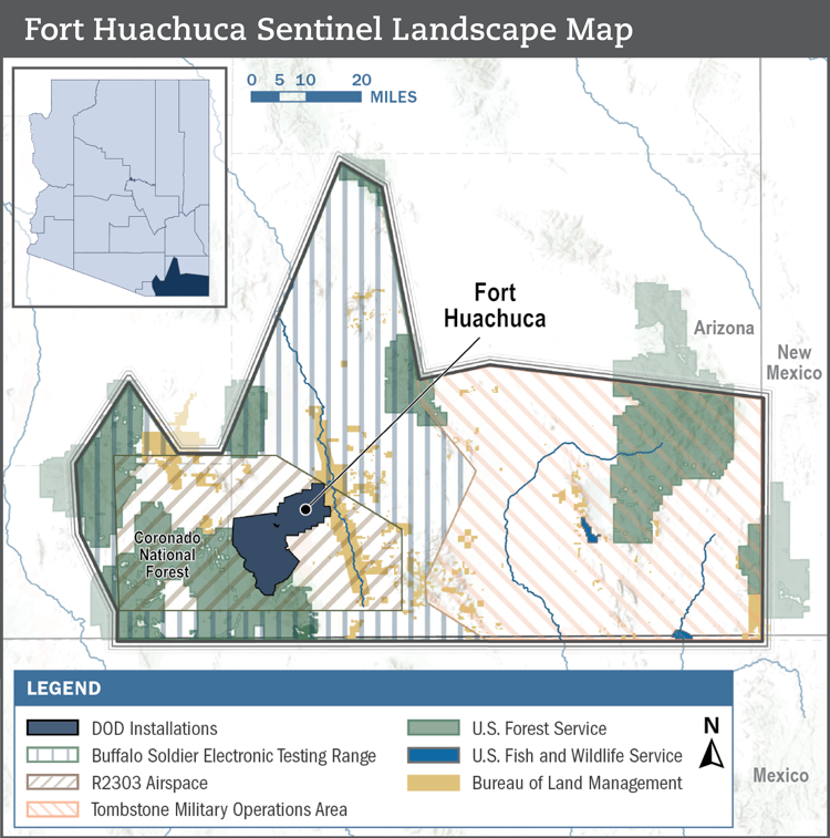
Located in southeastern Arizona, Fort Huachuca is the home of the U.S. Army Intelligence Center of Excellence and the Network Enterprise Technology Command. As a Major Range Test Facility Base, Fort Huachuca is a hub for electromagnetic technology testing and training and is one of the most extensive unmanned aerial vehicle training facilities globally. Fort Huachuca is also the largest employer in Cochise County and has the largest economic impact of any military installation in Arizona. Protecting this valuable economic asset is vital to Arizonans’ prosperity and national security.
The arid, remote landscape surrounding Fort Huachuca features broad grassland valleys and forested mountain ranges, predominantly used for livestock grazing. This open space is essential to the installation’s mission, helping to minimize electromagnetic interference and maintain effective training conditions. However, increasing development pressure is driving population growth and straining the region’s natural resources. As a result, the area faces rising water demand, heightened wildfire risk, habitat fragmentation, and encroachment on Fort Huachuca’s critical airspace and electronic range.
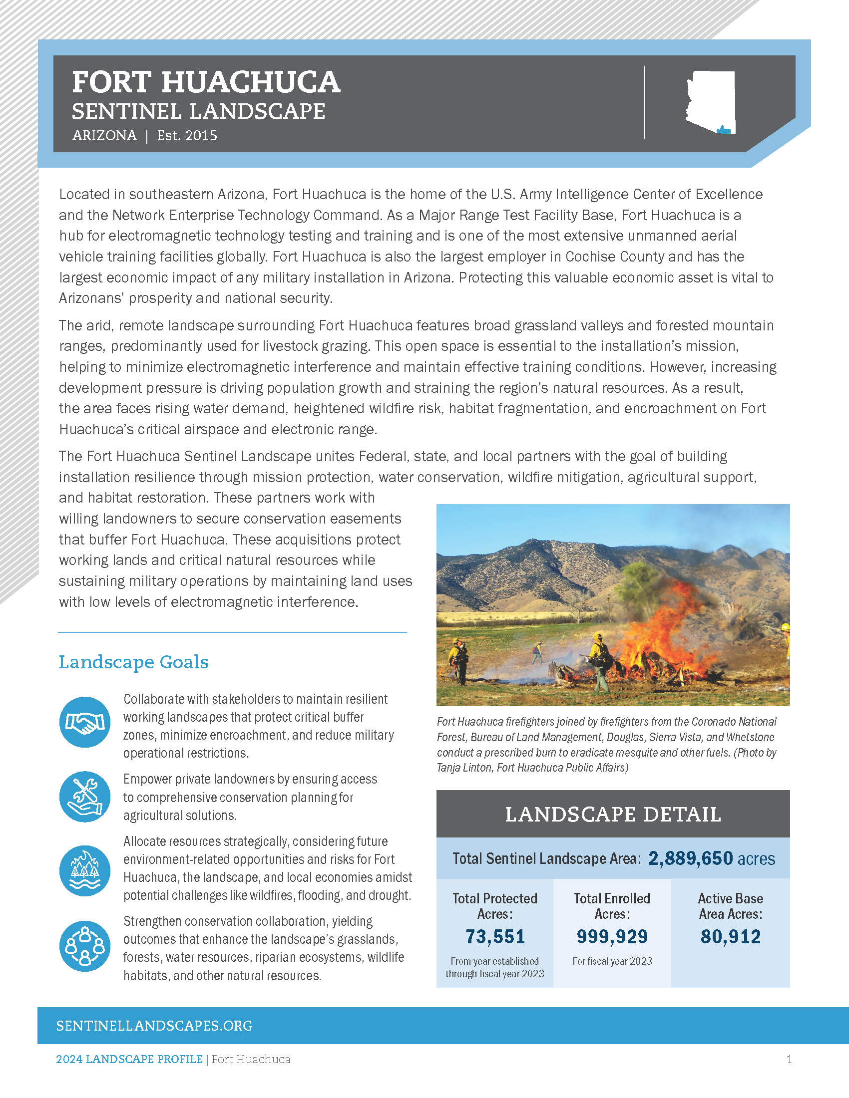
The Fort Huachuca Sentinel Landscape unites Federal, state, and local partners with the goal of building installation resilience through mission protection, water conservation, wildfire mitigation, agricultural support, and habitat restoration. These partners work with willing landowners to secure conservation easements that buffer Fort Huachuca. These acquisitions protect working lands and critical natural resources while sustaining military operations by maintaining land uses with low levels of electromagnetic interference.
Fort Huachuca Sentinel Landscape Documentary
Total Funding by Partner
| Partner | FY2014 | FY2015 | FY2016 | FY2017 | FY2018 | FY2019 | FY2020 | FY2021 | FY2022 | FY2023 |
|---|---|---|---|---|---|---|---|---|---|---|
| USDA | $0.51M | $1.13M | $0.58M | $0.99M | $3.13M | $2.28M | $1.13M | $3.02M | $0.65M | $2.16M |
| DOW | $0.00M | $0.00M | $0.00M | $0.00M | $0.00M | $0.00M | $0.00M | $0.00M | $0.00M | $0.00M |
| DOI | $0.06M | $0.08M | $0.21M | $0.03M | $0.07M | $1.64M | $0.05M | $0.00M | $0.02M | $0.15M |
| State | $0.45M | $1.21M | $1.57M | $0.58M | $1.01M | $0.73M | $0.22M | $0.11M | $0.29M | $0.48M |
| Local | $2.70M | $0.00M | $0.00M | $0.00M | $0.00M | $0.58M | $0.45M | $0.28M | $0.39M | $0.35M |
| Private | $0.00M | $1.06M | $0.12M | $0.11M | $0.82M | $0.09M | $4.12M | $2.49M | $0.00M | $0.00M |
| DoD | $5.00M | $0.00M | $2.66M | $0.63M | $4.11M | $1.07M | $2.22M | $1.63M | $5.70M | $4.50M |
Total Acres Protected and Enrolled
| Acres Protected (Since Designation) | 73551 |
|---|---|
| Acres Enrolled (During FY23) | 999930 |
Our Partners
Federal Partners
- U.S. Army
- U.S. Department of Agriculture, Farm Service Agency (FSA)
- U.S. Department of Agriculture, Forest Service (USFS)
- U.S. Department of Agriculture, Natural Resource Conservation Service (NRCS)
- U.S. Department of the Interior, Bureau for Land Management (BLM)
- U.S. Department of the Interior, Fish and Wildlife Service (USFWS)
- U.S. Department of War, Readiness and Environmental Protection Integration (REPI)
- U.S. Geological Survey
State Partners
- Arizona Department of Agriculture
- Arizona Department of Emergency and Military Affairs
- Arizona Department of Environmental Quality
- Arizona Department of Forestry and Fire Management (DFFM)
- Arizona Department of Water Resources
- Arizona Game and Fish Department
- Arizona State Land Department
- University of Arizona College of Agriculture, Life and Environmental Sciences
- University of Arizona Cooperative Extension
Local Partners
- Cienega Watershed Partnership
- City of Sierra Vista
- Cochise Conservation & Recharge Network
- Cochise County
- Fort Huachuca
- Fry Fire District
- Hereford Natural Resource Conservation District
- Huachuca City
- San Pedro Natural Resources Conservation District
- Santa Cruz County
- Santa Cruz Natural Resource Conservation District
- Sonoran Joint Venture
- Upper San Pedro Partnership
- Whitewater Draw NRCD
- Wilcox-San Simon Natural Resources Conservation District
Private Partners
- Appleton-Whittell Research Ranch
- Arizona Antelope Foundation
- Arizona Association of Conservation Districts
- Arizona Land and Water Trust
- Borderlands Restoration
- Cuenca Los Ojos
- Desert Landscape Conservation Cooperative
- Malpai Borderlands Group
- National Audubon Society
- National Fish and Wildlife Foundation
- Pheasants Forever
- Sky Island Alliance
- The Nature Conservancy
- Trust for Public Land
- Tuscon Audubon Society
Resources
-
Fort Huachuca Landscape Profile
Meet the Coordinator

Meghan LaPointe (Resilience Specialist)
Meg joined LegacyWorks Group in 2024 as the Fort Huachuca Sentinel Landscape Resilience Specialist. She holds a Master of Science in Environmental Conservation from the University of Wisconsin-Madison, a Bachelor of Fine Arts degree from the University of Wisconsin-Whitewater, and an Associate of Applied Science degree in Graphic Design from Western Technical College. For her Master's capstone project, she collaborated with American Bird Conservancy, Oregon State University, USFS Siuslaw National Forest, and Oregon Parks and Recreation using GIS to prioritize recreation areas for enrollment in a conservation campaign for Marbled Murrelet seabirds.
In 2022, Meg joined The Conservation Fund as the Milwaukee Program Coordinator in Wisconsin. She assisted the Milwaukee Metropolitan Sewerage District in operating two flood prevention programs spanning seven counties. As a member of the Milwaukee River Watershed Conservation Partnership (MRWCP), she worked with agricultural producers, local and state governments, and land trusts to purchase land development rights and protect hydric soils.
With a passion for cartography and graphics, Meg is interested in exploring the intersection of GIS and visual design to communicate compelling spatial stories. Additionally, she serves on the Board of Directors of the Southern Wisconsin Land Conservancy and enjoys birdwatching and hiking in her free time.