Middle Chesapeake Sentinel Landscape
-
Maryland
-
Established 2015
About
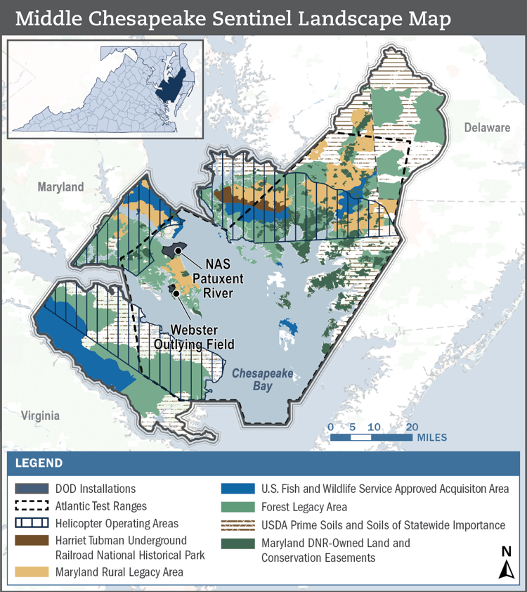
The Middle Chesapeake Sentinel Landscape spans over two million acres across the lower Chesapeake Bay in Maryland, Virginia, and Delaware. It is home to Naval Air Station (NAS) Patuxent River-Atlantic Test Ranges, one of the U.S. Navy’s premier aircraft testing locations. Each year, the U.S. Navy conducts over 150,000 testing and research flights within its 1.5-million-acre special use airspace in the region. The surrounding ecosystem is equally valued for its natural beauty, economic productivity, and ecological vitality, and it includes a portion of America’s largest estuary, the Chesapeake Bay.
Despite the landscape’s historically agricultural and fishing-based economy, its location makes it an increasingly attractive area for residential and vacation home development. This growing demand presents a challenge for the partners within the sentinel landscape, whose individual missions can conflict with unfettered development. As a result, in 2015, a group of stakeholders formed the Middle Chesapeake Sentinel Landscape to enhance land protection and restoration efforts across the region to support military readiness, working and natural lands, and resilient communities and ecosystems. Since its inception, the MCSL has grown from an initial group composed of Federal agency partners to include representatives from 40 different organizations and agencies.
Total Funding by Partner
| Partner | FY2014 | FY2015 | FY2016 | FY2017 | FY2018 | FY2019 | FY2020 | FY2021 | FY2022 | FY2023 |
|---|---|---|---|---|---|---|---|---|---|---|
| USDA | $4.03M | $5.12M | $6.24M | $4.06M | $3.36M | $4.78M | $3.47M | $4.87M | $5.11M | $3.29M |
| DOW | $0.00M | $0.00M | $0.00M | $0.00M | $0.00M | $0.00M | $0.00M | $0.00M | $0.00M | $0.00M |
| DOI | $1.01M | $1.28M | $1.95M | $0.69M | $0.37M | $0.87M | $7.15M | $0.93M | $0.00M | $1.97M |
| State | $1.88M | $2.26M | $3.23M | $4.28M | $2.15M | $8.00M | $8.95M | $11.65M | $10.14M | $4.33M |
| Local | $0.00M | $1.26M | $0.00M | $2.01M | $0.00M | $3.90M | $0.62M | $1.62M | $1.26M | $0.38M |
| Private | $1.67M | $0.04M | $0.54M | $0.84M | $0.36M | $1.37M | $0.72M | $2.83M | $5.83M | $4.43M |
| DoD | $3.00M | $1.00M | $1.50M | $1.54M | $0.65M | $3.63M | $6.15M | $1.50M | $4.84M | $5.02M |
| NOAA | $0.00M | $0.00M | $0.00M | $0.00M | $0.00M | $0.00M | $0.00M | $0.19M | $0.00M | $0.00M |
Total Acres Protected and Enrolled
| Acres Protected (Since Designation) | 63242 |
|---|---|
| Acres Enrolled (During FY23) | 123939 |
Our Partners
Federal Partners
- Naval Air Station Patuxent
- U.S. Department of Agriculture, Natural Resource Conservation Service (NRCS)
- U.S. Department of the Interior, Fish and Wildlife Service (USFWS) Chesapeake Bay Field Office
- U.S. Department of the Interior, National Park Service (NPS)
- U.S. Department of War, Readiness and Environmental Protection Integration (REPI)
Local Partners
Private Partners
- Chesapeake Conservancy
- Eastern Shore Land Conservancy
- Lower Shore Land Trust
- Nanticoke River Watershed Conservancy
- Northern Neck Land Conservancy
- Patuxent Tidewater Land Trust
- Southern Maryland Resource Conservation and Development Board, Inc.
- Sussex County Land Trust
- The Conservation Fund, Maryland and Delaware
- The Nature Conservancy, Maryland
- Trust for Public Land
- Virginia Outdoor Foundation
Resources
-

Middle Chesapeake Sentinel Landscape Profile
Meet the Coordinators

Emily Thorpe
JBO Conservation, LLC serves as the Coordinator of the Middle Chesapeake Sentinel Landscape partnership, helping to bring together federal and state agencies, land trusts, and local governments to advance joint goals across portions of Southern Maryland, the Delmarva Peninsula, and the Northern Neck of Virginia. With Joanna Ogburn and Emily Thorpe providing partnership coordination and Hilary Gibson supporting communications and project management, JBO Conservation brings over 40 years of collective experience in building and facilitating multi-stakeholder collaborative partnerships and advancing shared goals related to environmental conservation, landscape resilience, and community engagement.

Hilary Gibson
JBO Conservation, LLC serves as the Coordinator of the Middle Chesapeake Sentinel Landscape partnership, helping to bring together federal and state agencies, land trusts, and local governments to advance joint goals across portions of Southern Maryland, the Delmarva Peninsula, and the Northern Neck of Virginia. With Joanna Ogburn and Emily Thorpe providing partnership coordination and Hilary Gibson supporting communications and project management, JBO Conservation brings over 40 years of collective experience in building and facilitating multi-stakeholder collaborative partnerships and advancing shared goals related to environmental conservation, landscape resilience, and community engagement.

Joanna Ogburn
JBO Conservation, LLC serves as the Coordinator of the Middle Chesapeake Sentinel Landscape partnership, helping to bring together federal and state agencies, land trusts, and local governments to advance joint goals across portions of Southern Maryland, the Delmarva Peninsula, and the Northern Neck of Virginia. With Joanna Ogburn and Emily Thorpe providing partnership coordination and Hilary Gibson supporting communications and project management, JBO Conservation brings over 40 years of collective experience in building and facilitating multi-stakeholder collaborative partnerships and advancing shared goals related to environmental conservation, landscape resilience, and community engagement.

Emily Johnson
Emily is the Resilience Specialist for the Middle Chesapeake Sentinel Landscape, where she works with a team of federal, state, local, and nongovernmental partners to provide technical assistance and advance land conservation, protection, and restoration projects that bolster resilience priorities across the landscape. Prior to joining the MCSL team in the fall of 2025, Emily facilitated and coordinated various resiliency-focused initiatives at the New York State Office of Parks, Recreation and Historic Preservation. She has worked in a variety of conservation-focused contexts, from international to local, and has a breadth of partnership development and spatial data analysis experience. Originally from Albuquerque, New Mexico, Emily holds a B.S. in Biology from the University of New Mexico and an M.S. in Environmental Policy and Planning from the University of Michigan.